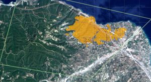
02/08/2021 Copernicus: Ο χάρτης με την καμμένη έκταση από την πυρκαγιά στην Αιγιάλεια Δείτε τον χάρτη του CopernicusEMS με την δορυφορική αποτύπωση των καμμένων εκτάσεων από την πυρκαγιά στην Αιγιάλεια Yesterday evening, our #RapidMappingTeam delivered the delineation map for the #wildfire which affected #Achaia #Αχαΐα, a region of #Peloponnese ?? ?Burn scar 400 ha ?Affected 383 Visualise it in our Activation Viewer at https://t.co/5UhPkApHJd#φωτια #Πυρκαγια #Ζήρια pic.twitter.com/oY2KQCc8wZ — […]